× Home Publications Presentations Datasets Documentation Curriculum Vitae News Resources GRACE Greenland Animation GRACE Antarctic Animation GRACE Months

Evaluation of reconstructions of snow/ice melt in Greenland by regional atmospheric climate models using laser altimetry data

by T. C. Sutterley, I. Velicogna, X. Fettweis, E. Rignot, B. Noël and M. van den Broeke
Geophysical Research Letters (2018)

Abstract:
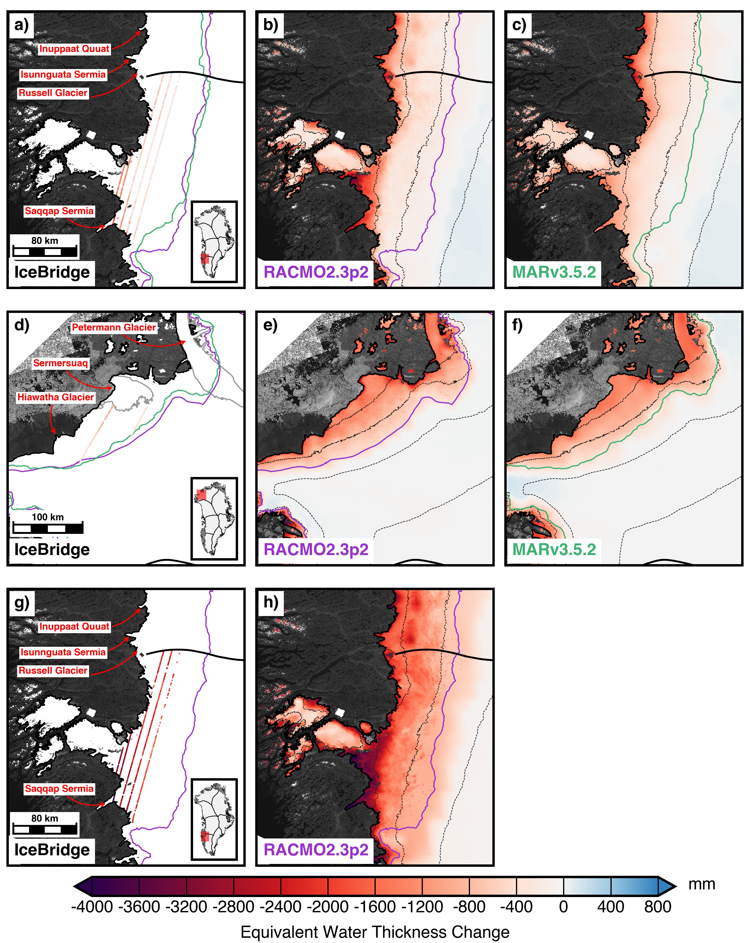
The surface mass balance (SMB) of the Greenland Ice Sheet critically depend on the intensity of ice/snow melt in its ablation zone, but in-situ data have been too limited to quantify the error of regional climate models. Here, we use 23 years of NASA satellite and airborne laser altimetry from the Airborne Topographic Mapper (ATM), Land, Vegetation and Ice Sensor (LVIS) and Ice, Cloud and land Elevation Satellite (ICESat) to generate time series of elevation change to compare with SMB products from the Regional Atmospheric Climate Model (RACMO2.3p2) and from the Modèle Atmosphérique Régional (MARv3.5.2). For 1994–2016, the results agree at the 15–26% level, with the largest discrepancy in north Greenland. During the cold summer 2015, the RMS discrepancy is 40% in the north, 30% in the southwest, and 18–25% at low elevation. The difference drops to 23% in the southwest and 14% at low elevation during the 2016 warm summer.

Caption: Comparisons of mass change from a,d,g) Operation IceBridge (OIB) laser altimetry, b,e,h) RACMO2.3p2 surface mass balance (SMB) and c,f) MARv3.5.2 SMB over the 2015 summer season for (a-c) Southwest Greenland and (d-f) North Greenland and over the 2016 summer season for (g-h) Southwest Greenland. OIB combines data from April 18, 2015 with data collected during 7 days in October 2015 for (a-c), data from May 5, 2015 and 2 days in October 2015 for (d-f) and data from May 14, 2016 with data collected during 6 days in August and September 2016 for (g-h). SMB outputs from MARv3.5.2 are not available for 2016. Purple and green lines are the ELA positions from RACMO2 and MAR, respectively, for the period 1993–2015. Gray lines in d) denote the 100 m/yr ice speed contour from Rignot et al. (2012). Thick black lines denote ice divides from Rignot et al. (2012). Dashed lines denote 500 m elevation contours from the Greenland Ice Mapping Project (GIMP) (Howat et al., 2014). Inset map denotes the location of the maps.
BibTeX Citation
Data Access
Article materials ©2018 American Geophysical Union